11/10 Day 9
We woke up amid a huge parking lot for Dettifoss, but it was abandoned. The beauty of being someplace in the wintry low season. We imagined this place was crawling with tourists during the high season. Eventually some cars did show up, but we had the place to ourselves for over an hour. Dettifoss is part of Jokulsargljufur, which is the far northern reaches of Vatnajokull NP. Jokulsargljufur protects a unique subglacial eruptive ridge and a 30km long canyon
The sunrise this morning was spectacular! It was a cold and frosty morning. We took the short trail to the super powerful falls and then continued on amongst old lava flows to the smaller Selfoss waterfall. When we made it back to the huge Dettifoss, the sun was up and there were rainbows in the mist of the falls. We went back to the car and then continued along the river along a rough dirt road until we reached Vesturdarlur. We got out here and did some hikes through some cool lava formations and along the river. Some really interesting basalt column formations. There was also a large lava cave called the kirkjan (church). Back at the car we continued North on the rough road until we reached Asbyrgi, which is a large horseshoe part of the canyon.
From the Asbyrgi canyon we headed North until we reached the coast. We continued along the coast until we reached the small former whaling village of Husavik. It's now still a whaling village of sorts, but a whale-watching village. It had a colorful harbor and a nice view of the mountains across the bay. We had wanted to get some fish and chips here as they had a walk up place that was supposed to be cheap. But it was closed for the season, so instead we treated ourselves to hotdogs at the N1 petrol station. A family that we saw eating there, left and left a huge plate of fries and a burger, so being the cheap backpackers we are, we finished off their meal too. haha! Nothing wasted.
We continued on towards Myvatn a large lake in a volcanic landscape. The dirt road went through a lunar-like landscape full of volcanoes that was emphasized by the giant moon we saw rising in the sunset as we drove through. We arrived to Myvatn just before dark. We were sort of wondering what we should do with the rest of the night since it was about 5pm. We headed to the hotsprings pool of course! But it was closed. So we went to a hotel that was listed to have hot pots. They no longer had them, but they had a really good happy hour deal, so we stopped in for a beer and free wifi. It was here that we found out the shocking results of the US election. Another beer please! The nice gals at the hotel told us where another nearby hot springs pool was, so we headed that way. As we were driving along, we saw some nice Auroras. The outdoor hotsprings pool was really nice and we soaked for a while. There were auroras when we went into the pool, but the outside lighting of the pool was too bright to watch the northern lights.
We decided to camp near Krafla which was a big geothermal area we had plans to visit. But when we got there, 2 things kept us from camping there. The 1st was that it smelled so strongly of sulfur that it was uncomfortable. The 2nd was, as we were sitting and debating, we both saw a strange white thing moving in the dark. At first we thought it was a horse or something. But it moved so sneakily and swiftly. We ended up deciding it must be a white-walker (from Game of Thrones). In the end it was probably steam from a geyser, but we were spooked and our nostrils hurt enough that we moved out a bit further and camped in a desolate area where we some some good northern lights.
11/11 Day 10
We woke up to some crazy winds. Today would end up being probably the overall windiest day we had, but from this day until I took off in Reykjavik, we would have pretty strong winds the rest of the time.
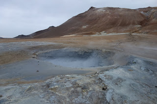
It was a busy day for us today. First we took a hike in Krafla's Lierhnjukur solfataras. This is Krafla's most impressive and perhaps most dangerous (if you wander of the marked paths) attraction. This area originally erupted in 1727, but there was another lava fountain eruption here (known as the Krafla fires) from 1975 and ongoing for 9 years. Now the area has bubbling mud, sulfur-encrusted fumeroles, steaming vents, and lots of lava formations. The crust in the area is super thin and the ground ferociously hot, so you better stay on the marked path! The path led around to little pools, bubbling mud areas, and some cool old craters amongst the old lava flows. The lava flows were giant black, frozen rivers.
After our hike, we drove up to Viti crater which has a nice turquoise colored pool at the bottom of it. Normally we would have walked around the crater, but it was so crazily windy that we just walked up part of it. It was so windy you could lean into the wind and sometimes the gusts would push you uncontrollably down the mountain. From the crater, we headed back down towards Myvatn passing the large geothermal power plant with it's growling fumeroles (Elisha said they sounded like T-rex). Along the way there was a continually running shower just sitting out in the open, of course heated by the hot springs. I took the opportunity to take a shower and rinse off.
The next place we visited was Hverir, which is a large martian like area with lots of cool fumeroles, bubbling mud holes, mud cauldrons, and cool little hotspring pools. We boiled some eggs to eat on one of the fumeroles.
Next we drove to Grjotagja, which was a really awesome place. There's a giant lava tube that has formed these little grottos. Inside are crystal clear hotsprings. They looked so inviting to take a dip, but the water was too hot (113F). Before the last eruptions in the 80's people used to soak in them, but after the eruptions they became too hot. On sunny days (and when the sun is higher in the sky) it's supposed to be cool b/c light filters in through the cracks of the lava tube. There was a famous scene from Game of Thrones with Jon Snow and Ygritte.
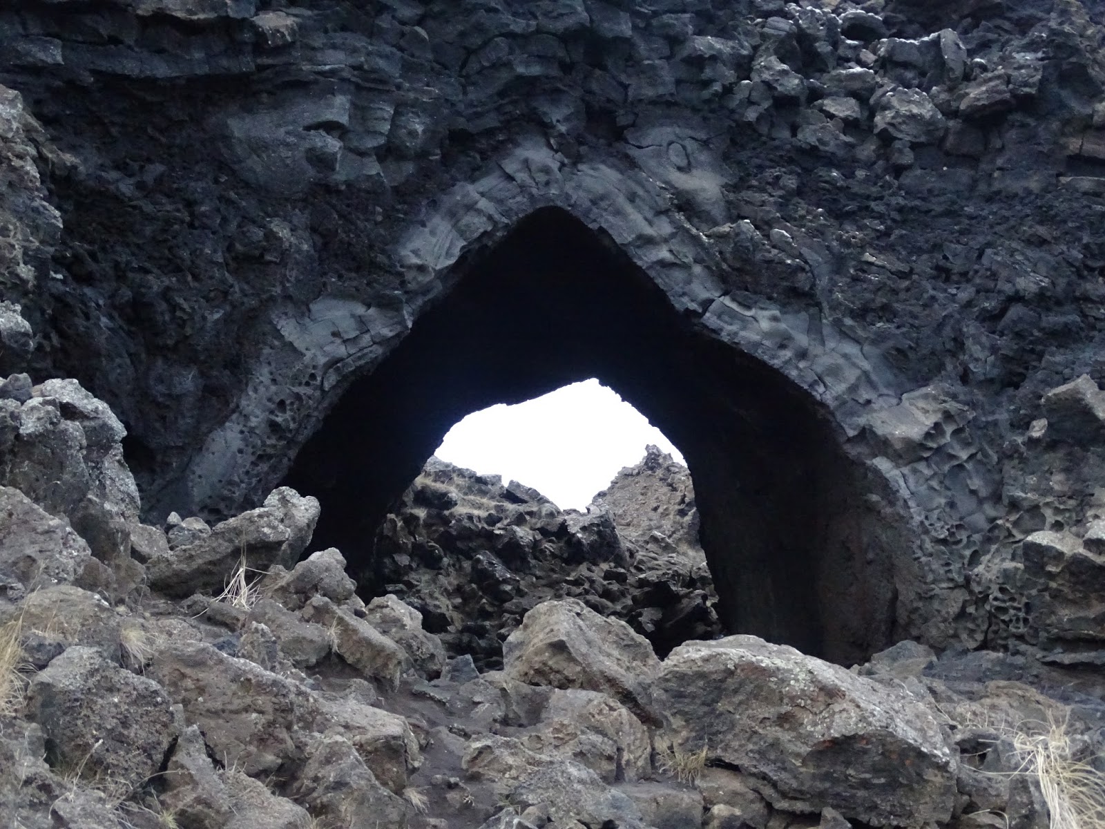
After Grjotagja we drove to Dimmuborgir (meaning dark castles), a jagged lava field where we took a nice little hike. There were lots of really cool lava formations that could look like trolls or elves. There were also several caves, including a large one called the kirkjan (church). And also some cool windows and arches that made for some cool photographs. Definitely a spectacular little hike.
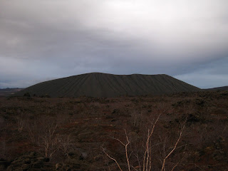
At dusk we took a short hike at Hofdi along the lake that had some interesting lava formations and also a little forest. Lastly, at nearly dark, we checked out a few of the super interesting pseudocraters along the lake at Skutustadagigar. The pseudocraters were formed when molten lava flowed in to the lake, triggering a series of gas explosions. The craters came into being when trapped, subsurface water boiled and "erupted"
There were some other cool volcanic features in the area I would have loved to check out, but with the short days and being on a bit of a tighter schedule due to the 4 day weather delay in Greenland, we had to keep moving, but we definitely had a good look at the main spots of interest in the area. We drove around to most, but in the summer when you have infinitely long days, you could actually connect them all by hikes.
From Myvatn we drove to Akureyri (where I had originally flown into) arriving in the night. Akureyri did have a grocery store open til 9, so we did some grocery shopping. We then continued on to Dalvik on Eyjafjordur to start a journey through Trollskagi (Troll Peninsula). We spent the night along the fjord just outside of Dalvik
11/12 Day 11
In the morning we drove to Olafsfjordur, which was reached by a 1 lane, 3km long tunnel. It was a pretty town along the water with steep mountains around. They had a cool looking pool with a couple of slides and a ski hill coming right into town as well as a ski jump right outside the pool.
After checking out Olafsjordur, we drove through an 11km tunnel which briefly opened up for a few hundred meters at Hedinsfjordur.
We went back to the intersection and then continued on the last 4km to reach Siglufjordur. This might have been my favorite fjord town, though it had close competition from Olafsfjordur. Siglu used to be a fairly big town (10,000 people), full of herring fishermen. However, when the herring population crashed in the North Atlantic, the town lost its main industry and most of its people. (Population is now 1,100). There's a herring museum there explaining it all. The town is picturesque with tall mountains coming right down to the fjord. It was also home to the biggest ski area that we saw on our trip (we went through Akureyri at night which has the bigger resorts). The ski area had what appeared to be about 5 poma lifts. We took Tyrion on a fun adventure up a steep and snowy (at the top) pass on the ski area, which gave us some nice mountain views and cool views down to the fjord.
As we were leaving town, we read some interesting tourist info boards about all the avalanche defenses that the town had set up. Not too long ago, some of these towns built below these steep mountains would periodically suffer mass casualties as well as economic devastation from avalanches. So the government stepped in and initiated different avalanche mitigation strategies that are pretty interesting. They first built up these metal fences on the steep slopes that help stabilize the snowpack. Then they have avalanche diversions that are meant to steer avalanches away from town. If the avalanche is too big and it goes over the diversions, the last line of defense are avalanche dams which keep the snow from reaching town. They did all this in a way that blends in with the mountains, so it's hardly noticeable. Pretty cool stuff. The only way out of Siglufjordur was of course through another single-lane tunnel.
We continued along the coast until we reached Hofsos sitting on Skagafjordur. From Hofsos there were nice views (when the rain showers would allow) across the fjord to to mountains on the next peninsula over. What Hofsos is famous for is its designer style endless pool that sits up on the cliffs overlooking the water. We were in need of a good cleaning, so we of course went for a swim. It was pretty sweet. The pool did feel like it just kept going forever into the fjord. In addition to the heated pool, there were some nice hot pots to soak in. I swam some laps in the pool, but quickly got too hot!
The pool closed at 3, so we still had a bit of daylight after we got out and thus continued our journey through Saudarkrokur (sauerkraut as Elisha called it), Blonduos, and on to Hvammstangi on the Vatnsnes peninsula. Hvammstangi is home to the arctic seal museum and research centre. I was hoping we might be able to see some seals in the lit up harbor, but alas there weren't any. The info board said the seals were further north on the peninsula. Due to time constraints, we decided to skip the Vatnsnes peninsula and head towards the Westfjords.
It was a long journey getting to the Westfjords on bumpy dirt roads that wound through various fjords and mountains and we arrived to our camping spot around midnight. Elisha finished watching Mystery, Alaska (she had fallen asleep while we watched it earlier) and also watched Dirty Dancing on the drive. We eventually camped near Reykjanes overlooking the island of Vigur in Isafjordur (not to be confused with the town of Isafjordur futher north)


We woke up amid a huge parking lot for Dettifoss, but it was abandoned. The beauty of being someplace in the wintry low season. We imagined this place was crawling with tourists during the high season. Eventually some cars did show up, but we had the place to ourselves for over an hour. Dettifoss is part of Jokulsargljufur, which is the far northern reaches of Vatnajokull NP. Jokulsargljufur protects a unique subglacial eruptive ridge and a 30km long canyon
The sunrise this morning was spectacular! It was a cold and frosty morning. We took the short trail to the super powerful falls and then continued on amongst old lava flows to the smaller Selfoss waterfall. When we made it back to the huge Dettifoss, the sun was up and there were rainbows in the mist of the falls. We went back to the car and then continued along the river along a rough dirt road until we reached Vesturdarlur. We got out here and did some hikes through some cool lava formations and along the river. Some really interesting basalt column formations. There was also a large lava cave called the kirkjan (church). Back at the car we continued North on the rough road until we reached Asbyrgi, which is a large horseshoe part of the canyon.
From the Asbyrgi canyon we headed North until we reached the coast. We continued along the coast until we reached the small former whaling village of Husavik. It's now still a whaling village of sorts, but a whale-watching village. It had a colorful harbor and a nice view of the mountains across the bay. We had wanted to get some fish and chips here as they had a walk up place that was supposed to be cheap. But it was closed for the season, so instead we treated ourselves to hotdogs at the N1 petrol station. A family that we saw eating there, left and left a huge plate of fries and a burger, so being the cheap backpackers we are, we finished off their meal too. haha! Nothing wasted.
We continued on towards Myvatn a large lake in a volcanic landscape. The dirt road went through a lunar-like landscape full of volcanoes that was emphasized by the giant moon we saw rising in the sunset as we drove through. We arrived to Myvatn just before dark. We were sort of wondering what we should do with the rest of the night since it was about 5pm. We headed to the hotsprings pool of course! But it was closed. So we went to a hotel that was listed to have hot pots. They no longer had them, but they had a really good happy hour deal, so we stopped in for a beer and free wifi. It was here that we found out the shocking results of the US election. Another beer please! The nice gals at the hotel told us where another nearby hot springs pool was, so we headed that way. As we were driving along, we saw some nice Auroras. The outdoor hotsprings pool was really nice and we soaked for a while. There were auroras when we went into the pool, but the outside lighting of the pool was too bright to watch the northern lights.
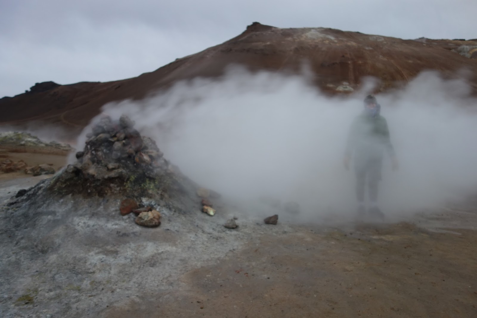
We decided to camp near Krafla which was a big geothermal area we had plans to visit. But when we got there, 2 things kept us from camping there. The 1st was that it smelled so strongly of sulfur that it was uncomfortable. The 2nd was, as we were sitting and debating, we both saw a strange white thing moving in the dark. At first we thought it was a horse or something. But it moved so sneakily and swiftly. We ended up deciding it must be a white-walker (from Game of Thrones). In the end it was probably steam from a geyser, but we were spooked and our nostrils hurt enough that we moved out a bit further and camped in a desolate area where we some some good northern lights.
11/11 Day 10
We woke up to some crazy winds. Today would end up being probably the overall windiest day we had, but from this day until I took off in Reykjavik, we would have pretty strong winds the rest of the time.
It was a busy day for us today. First we took a hike in Krafla's Lierhnjukur solfataras. This is Krafla's most impressive and perhaps most dangerous (if you wander of the marked paths) attraction. This area originally erupted in 1727, but there was another lava fountain eruption here (known as the Krafla fires) from 1975 and ongoing for 9 years. Now the area has bubbling mud, sulfur-encrusted fumeroles, steaming vents, and lots of lava formations. The crust in the area is super thin and the ground ferociously hot, so you better stay on the marked path! The path led around to little pools, bubbling mud areas, and some cool old craters amongst the old lava flows. The lava flows were giant black, frozen rivers.
After our hike, we drove up to Viti crater which has a nice turquoise colored pool at the bottom of it. Normally we would have walked around the crater, but it was so crazily windy that we just walked up part of it. It was so windy you could lean into the wind and sometimes the gusts would push you uncontrollably down the mountain. From the crater, we headed back down towards Myvatn passing the large geothermal power plant with it's growling fumeroles (Elisha said they sounded like T-rex). Along the way there was a continually running shower just sitting out in the open, of course heated by the hot springs. I took the opportunity to take a shower and rinse off.
The next place we visited was Hverir, which is a large martian like area with lots of cool fumeroles, bubbling mud holes, mud cauldrons, and cool little hotspring pools. We boiled some eggs to eat on one of the fumeroles.
Next we drove to Grjotagja, which was a really awesome place. There's a giant lava tube that has formed these little grottos. Inside are crystal clear hotsprings. They looked so inviting to take a dip, but the water was too hot (113F). Before the last eruptions in the 80's people used to soak in them, but after the eruptions they became too hot. On sunny days (and when the sun is higher in the sky) it's supposed to be cool b/c light filters in through the cracks of the lava tube. There was a famous scene from Game of Thrones with Jon Snow and Ygritte.
After Grjotagja we drove to Dimmuborgir (meaning dark castles), a jagged lava field where we took a nice little hike. There were lots of really cool lava formations that could look like trolls or elves. There were also several caves, including a large one called the kirkjan (church). And also some cool windows and arches that made for some cool photographs. Definitely a spectacular little hike.
At dusk we took a short hike at Hofdi along the lake that had some interesting lava formations and also a little forest. Lastly, at nearly dark, we checked out a few of the super interesting pseudocraters along the lake at Skutustadagigar. The pseudocraters were formed when molten lava flowed in to the lake, triggering a series of gas explosions. The craters came into being when trapped, subsurface water boiled and "erupted"
There were some other cool volcanic features in the area I would have loved to check out, but with the short days and being on a bit of a tighter schedule due to the 4 day weather delay in Greenland, we had to keep moving, but we definitely had a good look at the main spots of interest in the area. We drove around to most, but in the summer when you have infinitely long days, you could actually connect them all by hikes.
From Myvatn we drove to Akureyri (where I had originally flown into) arriving in the night. Akureyri did have a grocery store open til 9, so we did some grocery shopping. We then continued on to Dalvik on Eyjafjordur to start a journey through Trollskagi (Troll Peninsula). We spent the night along the fjord just outside of Dalvik
11/12 Day 11
In the morning we drove to Olafsfjordur, which was reached by a 1 lane, 3km long tunnel. It was a pretty town along the water with steep mountains around. They had a cool looking pool with a couple of slides and a ski hill coming right into town as well as a ski jump right outside the pool.
After checking out Olafsjordur, we drove through an 11km tunnel which briefly opened up for a few hundred meters at Hedinsfjordur.
We went back to the intersection and then continued on the last 4km to reach Siglufjordur. This might have been my favorite fjord town, though it had close competition from Olafsfjordur. Siglu used to be a fairly big town (10,000 people), full of herring fishermen. However, when the herring population crashed in the North Atlantic, the town lost its main industry and most of its people. (Population is now 1,100). There's a herring museum there explaining it all. The town is picturesque with tall mountains coming right down to the fjord. It was also home to the biggest ski area that we saw on our trip (we went through Akureyri at night which has the bigger resorts). The ski area had what appeared to be about 5 poma lifts. We took Tyrion on a fun adventure up a steep and snowy (at the top) pass on the ski area, which gave us some nice mountain views and cool views down to the fjord.
As we were leaving town, we read some interesting tourist info boards about all the avalanche defenses that the town had set up. Not too long ago, some of these towns built below these steep mountains would periodically suffer mass casualties as well as economic devastation from avalanches. So the government stepped in and initiated different avalanche mitigation strategies that are pretty interesting. They first built up these metal fences on the steep slopes that help stabilize the snowpack. Then they have avalanche diversions that are meant to steer avalanches away from town. If the avalanche is too big and it goes over the diversions, the last line of defense are avalanche dams which keep the snow from reaching town. They did all this in a way that blends in with the mountains, so it's hardly noticeable. Pretty cool stuff. The only way out of Siglufjordur was of course through another single-lane tunnel.
We continued along the coast until we reached Hofsos sitting on Skagafjordur. From Hofsos there were nice views (when the rain showers would allow) across the fjord to to mountains on the next peninsula over. What Hofsos is famous for is its designer style endless pool that sits up on the cliffs overlooking the water. We were in need of a good cleaning, so we of course went for a swim. It was pretty sweet. The pool did feel like it just kept going forever into the fjord. In addition to the heated pool, there were some nice hot pots to soak in. I swam some laps in the pool, but quickly got too hot!
The pool closed at 3, so we still had a bit of daylight after we got out and thus continued our journey through Saudarkrokur (sauerkraut as Elisha called it), Blonduos, and on to Hvammstangi on the Vatnsnes peninsula. Hvammstangi is home to the arctic seal museum and research centre. I was hoping we might be able to see some seals in the lit up harbor, but alas there weren't any. The info board said the seals were further north on the peninsula. Due to time constraints, we decided to skip the Vatnsnes peninsula and head towards the Westfjords.
It was a long journey getting to the Westfjords on bumpy dirt roads that wound through various fjords and mountains and we arrived to our camping spot around midnight. Elisha finished watching Mystery, Alaska (she had fallen asleep while we watched it earlier) and also watched Dirty Dancing on the drive. We eventually camped near Reykjanes overlooking the island of Vigur in Isafjordur (not to be confused with the town of Isafjordur futher north)


 |
| white walkers! |
 |
| land of fire and ice |


 |
| nice shower! |


 |
| boiling eggs |

 |
| finished products |
 |
| tasty! |
 |
| famous cave hot springs from game of thrones |


 |
| lake Myvatn |


 |
| the one place we stopped for happy hour in all of iceland and found out the election results |
 |
| hot springs rules |


 |
| windy! |


 |
| endless hotsprings pool! |


No comments:
Post a Comment