12-31
I had originally intended to go to Sikkim today, but b/c I liked the French couple so much and they were trying to organize a New Year’s Eve party, I figured it would be much more fun to stay and celebrate NYE with some friends rather than likely by myself in remote Sikkim (you need a special permit to even get into Sikkim). This along with the fact that I really needed to use a lot of internet to work on figuring out booking Indian trains (this is really quite difficult as they get booked so far in advance, but there are lots of tricks to getting more less last minute tickets. I can’t book far in advance b/c I never know how long I will stay, but I can’t waste too many days sitting around waiting for trains as I have an aggressive schedule with lots to see and just a bit over 2 months to do it.) I also needed to deal with some stuff for applying for an Antarctica position. Unfortunately the power was out for half the day, but I still had some time to get stuff done.
I also did some touring stuff and in the morning took the cute toy train from Darjeeling to Ghoom 10 kms away and then walked back checking out the views of Darjeeling.
In the evening I met up with the french couple, Sago and Ben, to have a new years feast of masala curry. We tried ordering a bunch of different drinks, but the restuarant was out of all of them. Finally we found they had long island ice teas, but it turned out to be mostly ice and I am pretty sure rum and coke. I guess the Gorkhas aren't quite into making cocktails yet. The town closes down at aroud 8 because of the 9 o'clock curfew, but we found a bar (with terrible karaoke) that would pretend to be closed and looke all locked up but be open until midnight. So we headed there, had a few beers, sang a few songs, and then did the countdown.
1/1/11 Happy New Year!
I had to say a sad goodbye to Wangchuck the owner of the homestay. I think he really liked me and he gave me a tibetan scarf to say goodbye and even a hug (I have noticed that Asians hardly hug). I took a jeep from Darjeeling to Johtan in Sikkim and then transerred onto another jeep to get to Pelling. I arrived in Pelling a few hours before dark and walked around a bit, thought it was quite foggy and cold (it's at 7100ft). But it is nice and quiet and friendly and has some good food.
1/2/11 I was quite surprised to wake up to gorgeously clear skies and amazing views of some very close mountains right from my hotel window.. Darjeeling had nice mountain views, but Pelling is much more in them. One of the mountains was of course Kanchenjunga as it is quite huge and dominating. Took a day long jeep tour in which me and 5 other Indian tourists visited 2 waterfalls, Khechuperi holy lake, Pemayagtse Monastery, and the Rabdentse ruins on the way to Yaksom. Rabdentse was the 2nd capital of Sikkim (during the 16th century). The driving itself was very nice and of course the roads were crazy with good views of little villages on steep mountains plunging down to river gorges.
Sikkim is an interesting place because it was an independent kingdom until 1975. It was then taken over by Nepal, then Tibet, then the British (not necessarily in that order) and finally decided to join India in order to protect itself from China. Because of this, they actually rule autonomously and you are required to get a separate permit to enter. Wangchuck helped me get the permit, so it was easy enough to get in. Because of the difficulties with the permit and being out of the way (the same is for the next place, Assam, that I am visiting) there are hardly any foreign tourists visiting the area, which makes it nice for India as it means there are not touts or hassling and the locals are genuinely friendly.) Sikkim is one of the places (along with Tibet, parts of Nepal, and part of China--which of course to promote tourism, China has actually named a city Shangri-la) that claims to be the fabled (and mythical) Shangri-la described by author James Hilton in his novel Lost Horizon.
1/3/11 Today I took a jeep to Siliguri and then a autorickshaw to NJP where I am now waiting for my night train. This was my first time in a real Indian city in the daylight (Darjeeling and Sikkim are much more tibet/nepal influenced). It was quite eye opening. Incredibly crazy traffic with streets full of bicycles, rickshaws, autorickshaws, jeeps, busses, trucks; all making one big mess with of course tons of honking. Trash everywhere and smells too. Cows wandering around. So many...so many street urchin kids and sick/disabled adults on the streets on top of beggars of course. People digging through trash and using the toilet just anywhere. So much noise and chaos for all of the senses. Well good thing is I won't be spending much time in cities I don't think other than as transit points and a few of the more touristic ones like Varanasi and Agra.
Friday, December 31, 2010
Singalila Ridge Circuit Trek
I had forgotten to mention in my last blog entry that after church on Christmas morning while we were outside having biscuits and Darjeeling tea, a whole horde of monkeys ran into the open doors of the Church. On the sign outside the church, they list mass times for English and Nepali (they speak Nepali in Darjeeling), but I guess they had forgotten to mention that they also have mass in Monkey. I think the monkeys enjoyed playing in the hay from the nativity scene and swinging from the rafters of the big cathedral.
So I had figured after I left Nepal that I was pretty much done with big trekking. However, once I got to Darjeeling and saw the Himalayas shimmering in the distance, I couldn’t resist. They beckoned me to come…mountains and me I guess. So I decided to do a 5 day trek on the Singalila Ridge Circuit. The weather was poor in Darjeeling at the moment, but Wangchuck told me that the weather would be good the next few days. He gave a very good description of how the weather works around here (the first I had heard from any local people anywhere in the Himalaya…no one ever seemed to know anything about weather or weather patterns when I would ask!). He said that in winter when there is bad weather and snow in the mountains, it will clear for several days and then slowly get bad again until it snows. So I had a short window of nice weather coming up, and I decided to go for it. Prateep, the Thai guy at the homestay, who had never trekked or anything, made a last minute decision to go partly because he was very intrigued by my description of trekking in the Himalayas, but mostly because he saw a few of my pictures from my blog and Eastern Asians (Thais, Chinese, Japanese) will never say no to an opportunity to take tons of gorgeous photos! It was funny b/c he was so excited to trek, but also so scared and nervous. I think he was very glad to have me to help him along. For this trek it was mandatory to have a guide, but the guide, Rajin, mainly walked with Prateep as he was quite a bit slower. We also had a porter, Bikash, for Prateep, but funny thing was that he had trouble keeping up carrying all of Prateep’s stuff, so I ended up carrying a bit of the stuff.
12-26 Day 1
Back to Nepal…
So in the morning, we set out for Many Bhanjang (2130m/6986ft) by jeep. It was very clear and sunny in Darjeeling and we had nice views of the Kanchenjunga massif as we drove away. The first day we trekked to Tumling (3100m/10,168). The walk the first couple of days was along the Nepal/India border, so there were lots of Indian border checkpoints where we had to show passports. And actually the first 2 nights we spent the nights in guesthouses that were actually in Nepal. The trek was sunny in the bottom, but Tumling was very foggy and cold, so Prateep and I just sat around the fire with a French guy doing just a 2 day trip. One of the nice things about trekking here in India was they would give us a hot water bladder to take to bed and put in our sleeping bag! Around the fire we enjoyed some Thumba, which is a local alcoholic drink in which water is poured into these seeds. You then drink the Thumba out of a bamboo straw.
12-27 Day 2
Frosty morning and gorgeous sunrise lighting up Kanchenjunga (3rd highest mountain in the world). I could also see Everest, Makalu (5th highest), Lhotse (4th highest), Nuptse, and other peaks in the Everest range. More alking along the border and a lot of up to get to Sandakpur (3636m/11,926ft) At a rest stop along the way, some kids gave me Himalayan chestnuts. So today seemed just like the song: “Chestnuts roasting on an open fire, jackfrost nipping at your door” as we had had frost that morning, a fire that night, and chestnuts today. First time I had ever had chestnuts actually. Sandakphu was above the clouds that had formed and thus had tremendous views of Kanchenjunga and the Everest range. It is much closer to the mountains and higher than Tumling, so that makes the views even nicer. Amazing, amazing! Sunset over the cloud sea and of course coloring the big mountains orange then pink. Met a nice couple from Vancouver (Helen and Ewen) and a nice couple from France (Sago and Ben) whom we would travel with the rest of the time. Prateep, these 4, and myself were the only people doing the circuit and we had a great time trekking together.
12-28 Day 3
Gorgeous sunrise painting Everest range and Kanchenjunga massif amber, pink, then orange. Very cold and windy, but it didn’t matter with the scenery. We walked 21km along the ridge to Phalut (3600m/11,808ft). Incredible views the whole walk: to the front was towering Kanchenjuna; to the left the Everest range; to the near right the mountains of Sikkim; and to the far right, the mountains of Bhutan. Amazingly crystal clear day too, so the mtns are especially clear. Watched an amazing sunset from a viewpoint near Phalut but in an ‘Estes Park in December’ type wind. From the viewpoint you could see Everest range in Nepal, Tibet Himalaya, Bhutan Himalaya, and of course the Indian Himalaya. There was a sea of clouds to the south towards the plains with smaller mountains rising just above the clouds like islands forming a really cool visual. And some of the clouds were flowing quickly over the low mtns forming a wave-like effect. Kanchenjunga is really close and just stood massively in front of us. Sweet! Sunset w/ all the mountains and clouds and fantastic lights.
12-29 Day 4
We all skipped the sunrise b/c it was so cold and windy and early and it would have been impossible to beat the sunset. But I did walk back up to the viewpoint after a chapati and potato curry breakfast to see the view again. The trail to Ramman (2530m/8298ft) was nice through bambook and forest and a cute (and warm!) village of Ghorkey.
12-30 Day 5
Nice trail through villages clinging to steep hillsides until reaching Rimbick (2290m/7511ft) were we took a jeep (16 people crammed into this one with 5 on top as well) for the 4 hours back to Darjeeling along a road that wound down one of the steepest mountains I had ever seen a road go down. The Thai guy was definitely very much freaking out as the jeep was often quite close to a 3,000 foot or so drop. And of course it was a one lane road but sometimes we had to maneuver somehow around oncoming jeeps or even large trucks. Back in Darjeeling we saw a nice sunset over the now storming Kanchenjunga.
Saturday, December 25, 2010
Christmas in Darjeeling
Darjeeling is an old British hill station (perched on a steep hill and ridge) famous for its teas, mountain views, and toy train (a miniature train originally built mainly for hauling produce). There are lots of old, European looking buildings here from the 1800’s when the British were occupying. So that is pretty cool and a bit of a change from the bland and terrible architecture of Nepal. It’s cold here, as it should be on Christmas Eve. I had a nice Christmas Eve breakfast with of course a hot cuppa the famous tea…and with some views of Kanchenjunga over the clouds. I am staying at a really nice homestay run by a super knowledgeable and helpful Tibetan guy named Wangchuk who keeps the hot teak coming all the time. He has 3 rooms in his apartment besides his: one is occupied by a Thai guy and the other by an apparently famous British photographer named Richard. Richard introduced me to two show musicians from London’s West End who are performing for the holidays at a very fancy resort here. The resort is unfortunately the only place having a special Christmas dinner, but it costs 45 bucks for the Christmas eve show and dinner and 85 bucks for the Christmas dinner and show and wine. I am willing to splurge a bit for Christmas, but not quite enough to spend a ski tickets worth on food that won’t be as good as the meal my mom will have for me when I get home anyways. So instead I had a nice meal of paneer tikka masala and momos for dinner. I also had various chocolate cakes and cookies from a nice bakery in town. I spent the day sort of chilling out around Darjeeling and exploring a bit. Went to a view point that had a Buddhist temple on it and some views of the mtns. I may be missing all the colorful Christmas lights, but the Tibetan flags on this hill more than made up for that! Also lots of monkeys playing around. I also spent some time finding a Church for the Christmas services. I found a Catholic church with a convent attached to it. I am in West Bengal, which is in the same state as Calcutta, so they had a nice memorial thing to Mother Theresa as well. The nun I talked to told me they weren’t having a midnight mass this year b/c of the curfew (there is a curfew here right now bc the Indian gov’t is concerned about the people here (known as Gorkhas) who want their independence and a new country called Gorkhaland, so instead I went to the 6pm caroling and then the 7pm mass. I was definitely the only white dude at the mass, but they did do some singing and the gospel in English, which was nice.
12-25 Merry Christmas!! Woke up at 4am to take a Jeep up to Tiger Hill. Went with Prateep from Thailand and Satoshi from Japan. Unfortunately it was a bit misty and cloudy so we couldn’t see Everest and the Everest Range and could just get a few glimpses of Kanchanjunga. After sunrise up on Tiger Hill, we went to the Batanga (?) loop where the toy train makes a loop around a war monument. Once back, Wangchuck made me breakfast. Satoshi and I went to the 10am Christmas Service at St. Andrew’s (Anglican). It was much different than the Catholic one—not in structure, but attendance. The Catholic one was all locals and packed to standing room only. It lasted 3 hours and was full of enthusiastic, though terribly off key (even tone deaf me could tell so I was able to belt it loudly with them) people. A very vibrant service. The Anglican one, which had been advertised in all the tourist places, was just ½ full and mostly tourists (quite the international crowd from slovenia to france to England to Canada to japan to Switzerland, etc) and quite subdued, though the carols were nice (one local guy did a beautiful rendition of Mary did you know, which made me really miss my mom since that is one of her faves). But like the Catholic mass, it ended with sweets and Darjeeling tea. I then went on a 12km walk in the hills around Darjeeling. I walked by the Himalayan mountaineering training association and Himalayan zoo, but didn’t feel like visiting. I then did a bit of climbing around Tenzing Rock which is named after Tenzing Norgay (if you don’t know who that is, shame on you!) who actually is from Darjeeling. The rock is now used to train aspiring mountaineers. I then visited the Tibetan Refugee camp and finished up at the Chitre Tea Garden Plantation where I drank plenty of tasty Darjeeling tea.
I met Satoshi at one of the nicer restaurants for our fancy Christmas dinner. I splurged ($7.50) on dinner with a mixed meat roast, tea, and chocolate icecream. Yum! Spent the evening watching movies with Prateep and Wangchuck at the homestay. Wangchuck also showed me some pictures on his computer of Camp Hale. Wow, how strange is that. Not as strange as you would think. Camp Hale (a winter/mountain army training camp between Leadville and Vail for those of you non-coloradoans) apparently was used by the CIA in the 50’s and 60’s to train Tibetans in guerilla mountain warfare to try and win their freedom and of course beat the Chinese. Wangchuk’s father had been one of those freedom fighters that was being honored at a Camp Hale thing. His father and 2 of his siblings now live in the states. I told him that in Boulder there is still a huge Free Tibet movement and he thought that was cool. We spent some time searching Tibet and Boulder on google and he loved looking at the menu (and prices…actually cheap for USA) of Tibet Kitchen on Arapahoe. We also found out that Boulder is the sister city to Lhasa and that there is a big freedom foundation sponsored by the Colorado Governor, Senator’s, Representatives, Coors family, and of course the true celebrity of Colorado, John Elway.
I just missed the Himalayas so much and missed the wild, that I have decided to do another trek. It will be 5 to 6 days and go out towards Kanchanjunga. So I leave early tomorrow for that. Wangchuck helped me organize it. He is so incredibly friendly and full of knowledge. He’s really a great guy! Oh and I forgot to mention that he gives you a boiling hot water bottle to take to bed to keep you warm at night. ALthought it is not the coldest temperatures by far I have ever had at Christmas, it is the coldest Christmas. This is b/c it gets below freezing at night and highs in the 40's, but they have no heat or anything here. At church you could see everyone's breaths as we sang and I really wished I could wear my hat in church. You sing extra loud to stay warm though
Welcome to India and Wacky day of travel
12-22 Hang out around Kathmandu. Get poste restante package from mom at the post office. Goodbye to Nepal dinner at one of my favorite restaurants in KTM. Lots of their tasty masala tea.
12/23 Decided to not take the long 20 hour bus to the border b/c of safety concerns with Nepalese night busses and breaking up the trip into several days would have meant traveling on Christmas Eve which wasn’t very desirable. On the plane they handed out newspapers and I read about a bus crash that had 20 people seriously injured near the town I would be flying into. So, took the noon flight to Bhadrapur at the very eastern side of Nepal after saying goodbye to Khem and the gang at Elbrus Home Hostel where I had stayed quite a lot. Flew Buddha airlines, which on its advertisement for comfort of its planes, boasted of 5’7” standing room, anti-collision radar, and bullet proof windows…hmmm…among other things. Thank God for those bullet proof windows! It was a tiny plane with about 14 seats and appeared to be from the 1960’s. Cotton was provided for the ears to keep the noise down. The flight was amazing though! Paralleled whole Himalaya range on a gorgeously clear day (you could even see the snow peaks from KTM). We flew by Everest, Makalu, Lhotse, Nuptse…all those big peaks I had trekked by. I also think I could see Mera Peak (the peak that I climbed). As we got further east, I also saw the massive Kanchenjunga (3rd highest peak in the world). When we landed in warm (it is only at 300ft altitude) Bhadrapur, we found out that that the local bus association who were members of the Maoists were on strike amid the increasing political confusion in Nepal. So I shared a minvan taxi with some Indians until we got 8km from the border. Then we found out the road was closed, so I had to take a Rickshaw (human powered tricycle type thing) the rest of the way to Karkabhitta. The poor guy was going so slow with me, my luggage and the other Indian guy and his luggage on the rickshaw. Since I enjoy bicycling, I offered to pedal. The driver was so happy for that and we got lots of looks and noises from people on the street as I flew by. I’m quite a bit bigger than these rickshaw drivers, so I was able to go much faster and we were passing everyone. But…apparently Rickshaws aren’t made to go so fast and something on the left axle broke causing that side of the rickshaw to tilt terribly to the left. At the speed we were going I couldn’t control this heavy left turning and we flew off the road and shot off a bank of about 10 feet. We didn’t fall the whole 10 feet as it was slightly sloped, but we did soon flip over. I imagine, with all our bags and us, it looked a lot like those crashes you see in movies where they are driving the very old convertible and the it goes over the edge and the suitcases fly everywhere and clothes fly out of the suitcases and it’s just a big mess. Though usually in the movies it is quite embarrassing for the guy in the car, but they have swerved to avoid some beautiful woman that they end up falling for. For me, there was no beautiful woman...just a bunch of trash and bushes in the ditch. No one got really hurt, though I was quite scratched up and bloody from cuts. This was not really how I wanted to cross into notoriously dirty disease ridden India…bleeding from open wounds. Before crossing the border, you can hire a taxi to take you to the main Indian city nearby that is about 1 hour away. B/c of the Nepalese strike, they thought I would fall for the lie that they were also striking in India. I just knew this was a scam, so I walked across the border (a long bridge) on my own and easily found a bus to Siliguri. By the time I got to Siliguri is was about 6pm and dark. I was told there was no more busses to Darjeeling b/c of the time. However, one thing I have learned in Asia is that you never really accept no. So I looked around and sure enough found a shared jeep thing going. We packed 12 people into the jeep and then headed up the steep winding road to Darjeeling. Siliguri is at 300 ft and Darjeeling at nearly 7000ft, so you can imagine what the 3 hr drive was like especially if you consider it takes about 2 hrs to go the same altitude gain from Denver to the tunnel and that is going 65 mph the whole time and not 20mph. So yea…really, really steep. As we approached cold Darjeeling I noticed a few houses with Christmas lights. This made me smile and was quite happy I was coming to Darjeeling for Christmas as I was feeling a bit homesick during this Christmas season, so I was grateful to be going to a place where there would be a bit of a Christmas celebration.
12/23 Decided to not take the long 20 hour bus to the border b/c of safety concerns with Nepalese night busses and breaking up the trip into several days would have meant traveling on Christmas Eve which wasn’t very desirable. On the plane they handed out newspapers and I read about a bus crash that had 20 people seriously injured near the town I would be flying into. So, took the noon flight to Bhadrapur at the very eastern side of Nepal after saying goodbye to Khem and the gang at Elbrus Home Hostel where I had stayed quite a lot. Flew Buddha airlines, which on its advertisement for comfort of its planes, boasted of 5’7” standing room, anti-collision radar, and bullet proof windows…hmmm…among other things. Thank God for those bullet proof windows! It was a tiny plane with about 14 seats and appeared to be from the 1960’s. Cotton was provided for the ears to keep the noise down. The flight was amazing though! Paralleled whole Himalaya range on a gorgeously clear day (you could even see the snow peaks from KTM). We flew by Everest, Makalu, Lhotse, Nuptse…all those big peaks I had trekked by. I also think I could see Mera Peak (the peak that I climbed). As we got further east, I also saw the massive Kanchenjunga (3rd highest peak in the world). When we landed in warm (it is only at 300ft altitude) Bhadrapur, we found out that that the local bus association who were members of the Maoists were on strike amid the increasing political confusion in Nepal. So I shared a minvan taxi with some Indians until we got 8km from the border. Then we found out the road was closed, so I had to take a Rickshaw (human powered tricycle type thing) the rest of the way to Karkabhitta. The poor guy was going so slow with me, my luggage and the other Indian guy and his luggage on the rickshaw. Since I enjoy bicycling, I offered to pedal. The driver was so happy for that and we got lots of looks and noises from people on the street as I flew by. I’m quite a bit bigger than these rickshaw drivers, so I was able to go much faster and we were passing everyone. But…apparently Rickshaws aren’t made to go so fast and something on the left axle broke causing that side of the rickshaw to tilt terribly to the left. At the speed we were going I couldn’t control this heavy left turning and we flew off the road and shot off a bank of about 10 feet. We didn’t fall the whole 10 feet as it was slightly sloped, but we did soon flip over. I imagine, with all our bags and us, it looked a lot like those crashes you see in movies where they are driving the very old convertible and the it goes over the edge and the suitcases fly everywhere and clothes fly out of the suitcases and it’s just a big mess. Though usually in the movies it is quite embarrassing for the guy in the car, but they have swerved to avoid some beautiful woman that they end up falling for. For me, there was no beautiful woman...just a bunch of trash and bushes in the ditch. No one got really hurt, though I was quite scratched up and bloody from cuts. This was not really how I wanted to cross into notoriously dirty disease ridden India…bleeding from open wounds. Before crossing the border, you can hire a taxi to take you to the main Indian city nearby that is about 1 hour away. B/c of the Nepalese strike, they thought I would fall for the lie that they were also striking in India. I just knew this was a scam, so I walked across the border (a long bridge) on my own and easily found a bus to Siliguri. By the time I got to Siliguri is was about 6pm and dark. I was told there was no more busses to Darjeeling b/c of the time. However, one thing I have learned in Asia is that you never really accept no. So I looked around and sure enough found a shared jeep thing going. We packed 12 people into the jeep and then headed up the steep winding road to Darjeeling. Siliguri is at 300 ft and Darjeeling at nearly 7000ft, so you can imagine what the 3 hr drive was like especially if you consider it takes about 2 hrs to go the same altitude gain from Denver to the tunnel and that is going 65 mph the whole time and not 20mph. So yea…really, really steep. As we approached cold Darjeeling I noticed a few houses with Christmas lights. This made me smile and was quite happy I was coming to Darjeeling for Christmas as I was feeling a bit homesick during this Christmas season, so I was grateful to be going to a place where there would be a bit of a Christmas celebration.
Tuesday, December 21, 2010
Jungle Safaris
12-17 Mailed of package of some gear home. It was an interesting way that they did it b/c instead of the standard box, they wrapped it up in some cloth, sewed it up, and then sealed it with wax. I had forgotten to give my guide Chongbwa from the Mera Peak trip a tip before, so I made sure to meet with him today and give him his well deserved tip. I also forgot to mention that when I visited Durbar Square yesterday they had a big display going on celebrating 60 (or something like that) years of the UN’s refugee organization. It made me feel a bit proud to be an American b/c most of the big posters and pictures and displays were about some refugee camp where the Americans were helping or sponsored and funded by Americans. There are a few things that are difficult and annoying when traveling, such as dealing with touts, always packing and unpacking, etc. But for me, as an American, one of the difficult thing is the very negative image of Americans by a lot of Europeans. Before people know you are American you will overhear them talking this or that bad about my home. And even once they know, they will often make remarks of negative things towards Americans. I try not to let it bother me, knowing that we are a huge country and it is really hard to generalize anything about us. Those of us in the west can be quite different than the Californians or East Coasters and especially from our politicians. I like to think of us in a sports sort of way, like the Yankees…everybody loves to hate the Yankees…and it is because they are good. So anyways, I try to just figure that they are a bit jealous or what not, but it was really nice to see this and have America portrayed in such a nice way!
12/18 Took the bus to Sauraha where Royal Chitwan National Park is. I went for a small walk along the river in the afternoon and saw a one horned Indian Rhino in the distance. Then as I continue walking, I look around the bend in the river and there is a big rhino walking in the river really close to me! It then moved across the river and into an open field where it grazed, and I could see it very clearly.
Crazy thing is even down here in the Terai (the Nepalese flatland), you can still see the snowcapped Annapurna range way off in the distance. Watched a sweet sunset over the jungle and the river tonight.
12/19 Had a 5 hour morning jungle walk. Crossed the river and then had a safety talk about what to do if you meet one of the dangerous animals (elephant, rhino, sloth bear, leopard, tiger). I laughed b/c the directions always included running behind the guide (in case I should lose my way, the guide said). I thought in my head that if something is running after me, I am certainly running past the guide if I am faster. I think that is the guide’s way of making sure he is safe! The one behind gets eaten! I had 2 guides. Weapons of protection…bamboo sticks (as opposed to Maasai guides who a least carried spears and lion clubs). On the walk we saw several spotted deer w/ some fawns and a big stag. Also saw some barking deer. Great hornbills among many birds. Heard a rhino, but couldn’t see it through the tall grass. Saw sloth bear termite digs and tiger claw marks and scat. Saw some Langurs and rhesus macaques playing in the trees. The guides were very nice and extremely knowledgable in ecology and natural history, quite the surprise for the typical Asian guides I have had. In Nepal, something that is a bit annoying is the very first thing that 99% of the people say to you is ’which country? ’ or ’where are you from’ which just bothers me b/c I would like a how are you? Or something else. We are not who we are based on our country. Anyways, sometimes just out of annoyance I say something different like Guam or Barbados. But with these guys I just made up a country completely. Amarnia. Now most of the time, the people asking are just touts so you never here from them again, but with these guys I had been telling a tout when I was near their office and they overheard. Being smart guys, they were inquisitive and wanted to know everything about Amarnia. So I had a fun time making up things about my country. It was located off of the Mexico and we spoke Spanish. They kept telling me I was the first person they had ever met from Amarnia…no doubt I was.
The land here is partly riverine forest, partly Sal forest, and also a fair amount of grassland of which most is very tall (8-10 feet tall) elephant grass, which can make spotting things difficult. The jungle here is sooo much better than the hot humid rainforest jungles of SE asia in my opinion. No nasty sweating and clothes that don’t dry. It was perfect temperature here as well, being the winter. Lows in the low 40s and highs in the low 70s. I had read in the papers in October that the Chitwan area had been having an epidemic of Dengue, so I had been nervous to go. But with heavy spraying and the dry and cold season coming it had ended. I hardly saw any mosquitos, but to be sure (considering I have had Dengue before and the 2nd time is much much worse with hemorrhagic dengue), I slept in my little mosquito tent at night and wore full clothing cover all day. It was interesting to learn, especially since I am quite interested in human-nature conflict and conservation biology, about the human/jungle history here. Up until the 1950s the Terai had been such a terrible malaria area (they had tons of it and a particularly potent strain) that no one could settle and live there. In effect, this saved the wildlife and jungle from what was happening in similar places like India and SE Asia…people moving in and cutting it down and hunting out the animals. Then sometime in the 50s there was a conflict in Kashmir (still sort of is) where the group that wanted independence (still does) was kicked out by both Pakistan and India. They had no where to go except escaping into Nepal, and once here, they had nowhere to go except the Terai. They found that by eating especially hot and spicy foods they could somewhat protect themselves from mosquitoes and malaria. But still many were being affected by and dieing from the disease. So Australia and the US came in with that famous chemical, DDT, and basically eradicated malaria from the Terai. Of course we know what effects DDT has on wildlife, especially birds eggs, but it was certainly quite good for the people. This eradication of Malaria allowed the Terai to become populated easily and soon most of the jungle was cut down and things like tigers, rhinos, elephants, gharials, etc were on the brink of local extinction in Nepal. Luckily a few national parks were set up and populations started to increase. But in the 90’s when the Maoists tried to take over the government and there was a lot of fighting in the park, the soldiers had to give up protecting the park and massive poaching occurred. But things have settled now and populations are again on the rebound. Interestingly with all the population development, they were now having Dengue epidemics as the dengue mosquitoes tend to breed more in urban areas.
Although there is no maoist rebellion per se going on, Nepal is still actually without a government. There hasn’t been a working government since I have been in Nepal. It is always the headlines in the paper, but nothing is being accomplished. Of course the Maoists are trying certain things and trying to rally students, but so far there has been no movement towards a working government at the moment. And actually, when I first got to Chitwan, the elephant mahouts (drivers) were on strike in some support or opposition to the Maoists. I couldn’t quite figure it out. Though they ended their strike in time for me to do a ride.
In the afternoon I took a jeep safari to go deeper into the jungle.. Saw some more spotted deer and a couple of wild boars. We stopped at the gharial (in the crocodile family) breeding center which was cool. On the way back we saw a rhino up really close that did a bluff charge at our little jeep. We also saw 3 mugger crocodiles and some monkeys. A British gal on the trip, Charlie, told us about her interesting job where she works for a company that organizes students to go to different countries and combine sightseeing with volunteering. So she gets to travel quite a bit to look for locations for the students to do projects and also go with the students.
12/20 Took a dugout canoe ride in the morning, which was nice and peaceful. Saw lots of birds including several types of kingfishers, a maribous stork, lots of peakcocks, a serpent eagle, some parrots, and many others. Saw 3 mugger crocs and the very endangered Gharial! Pushba (my guide) invited me to his house to meet his wife, Sita, and son. Sita made me the traditional Nepali meal of Dal Bhaat. After lunch I took a hike along the river and saw a large mugger croc. In the afternoon I went on an elephant safari. I saw a Sambar deer and lots and lots of spotted deer and peacocks, and a huge mugger croc. It is a really cool experience going through the thick jungle so high up on top of the giant elephant and crossing the deep rivers too. Elephants are the ultimate jungle vehicle. A great perspective of the jungle being so high up. And animals are not so afraid when you are on the elephant so that you can get much closer. In the evening I shared some beers with Pushba and another guide, Rama.
12/21 Took a very early microbus back to Kathmandu so that I could get there before the post office closed as I was hoping that a package with some medicine my mom had sent poste restante had made it as it hadn’t before I left. Unfortunately it hadn’t! So now I am trying to decided how long to stay b/c I would really like to get to Darjeeling and India for Christmas. As I have mentioned, the roads in Nepal are crazy. They are like a combination of the big Thompson canyon and trail ridge road and independence pass, except without good pavement. So nepalis (for some reason it is always the nepalis, don’t know if it is genetic or just not used to cars) are always getting sick and puking. So far I had been lucky and never sat by any pukers, but this morning I was sitting in the back seat with mother and daughter who both were puking the whole way!
It is even colder in KTM now. Tonight is supposed to go below freezing. Now of course this doesn’t sound too bad as it is December; however, Nepal isn’t really set up for much cold so nothing is insulated and it just feels colder than when say it is in the 20s back home.
Friday, December 17, 2010
Gorgeous Pokhara again...and then onto Kathmandu
If you ask what Trek I liked better between the Everest region and the Annapurna region, it would be tough to say. Everest had much more spectacular big mountain and alpine scenery, but Annapurna had much more variety. Ann, one of the gals I had met at Gokyo, said that Annapurna was a more quality trek, which I agree with. The trekking days are longer there bc you dont have to be as worried about altitude. And b/c you are at lower altitudes you get to see more village life and families and what comes with all that. There is also much more diverse landscapes on the trek, different cultures and foods and all that. And b/c it was a circuit, you run into less people on the trail and have it more to your self since everyone is going the same direction. Also since everyone is going the same direction and doing the same basic route, you meet up with a sort of group of people that you always see and hang out with during the trek, which was cool. Our group involved of course Eva, David, and I, but also a father and son from California, a father and son from New Zealand, 2 women from Boulder, A trio of 2 english and a dutch, and the 4 from Flagstaff. Of course, I was in Everest during the crazy high season, and in Annapurna during the low season, which I am sure made a difference. Annapurna, b/c things arent flown in and there is more road access, costs about 1/2 as much as Everest for all the food and supplies. And b/c it was low season and the lodges make most of their money on food, my trio was always able to get our own individual rooms with blankets for completely free. So that was cool! This trek, maybe partly b/c it was the low season, just seemed to have more comeraderie than the Everest trek. And there werent any of those huge massive tour groups which was nice.
12/14 Got up very early to take a motorbike up to Sarangot again as the last time I went the sunrise hadnt been too good. This time I had that amazing sunrise that they all rave about. Spent the rest of the morning exploring old pokhara by motorbike and visiting the Seti River gorge. Spent the afternoon enjoying the culinary delights (yoghurt, lassies, bakery, chais) of Pokhara before having a farewell tea with David (he still wasnt feeling too good). Got my manly himalayan beard (I had complete about 2.5 months of hairy himalaya and no-shave Nepal) today by a barber who also gives a full head, neck, and shoulder massage for a buck fifty. But I kept the gross pedo-stache in honor of Beaver Creek Villate Transportation and Manly man (ask Lucas Stringfield if you want the inside to that joke).
12/15 Got up early to see sunrise over the Annapurna range from Phewa Lake one last time, from my favorite German bakery. Then bus to Kathmandu. Back in Kathmandu I kept myself busy looking at and into Antarctica jobs online.
Kathmandu isnt the nicest place to be right now as it is pretty cold (lows in the upper 30s to lower 40s and highs in the upper 50s) and the buildings arent built for cold and insulation here. Also, when I first got to Nepal, they were having powercuts of 5 hours per day. It then moved up to 6, and now it is at 8 hours per day1 At the start of the new year, they will be cutting power 12-16 hours per day. So that can kind of be an annoyance, especially in a city. But had a very delicious Indian meal by candlelight.
12/16 First day that I actually did a sightseeing thing in Kathmandu. Visit the Kathmandu Durbar Square where the royal family used to live. Visit Freak St (the old tourist ghetto) and then wonder around and lose myself in the narrow streets around Durbar square.
I havent talked much about Kathmandu itself. I dont particularly like it. I love Pokhara much better. The tourist ghetto, is knows as Thamel, and it is a crowded, noisy place. Tons of touts, narrow streets that still have cabs and pedicabs and motorbikes going through them. I think there is much more danger of breaking a leg by getting run over by a cab or bike in thamel than there is of doing the same while trekking. Kathmandu is similar to how I think most people would picture an Indian city. It not only has the noise pollution, but is dirty and smelly, especially outside of Thamel. On the walk to the post office you have to be very careful so as not to step in all the human feces along the way. Of course there are plenty of beggars, homeless, kids sniffing glue, etc. But the majority of the people you meat are quite nice, and in the back streets it is much more interesting and the noise dies down a bit and the smells become more pleasant (curries and spices). My guesthouse is very nice and I spend a lot of time hanging out onthe rooftop at it or watching movies in my room bc I dont have much of an urge to go explore in Kathmandu, unlike how I felt in other capitals like Bangkok or KL or something. If you are coming to Nepal, I would definitely recommend that you try and base yourself out of Pokhara as much as possible as it is so much nicer than KTM.
Annapurna Circuit/Around Annapurna Trek
11/29 (Day 1) Met a Belgian named David while eating a cinnamon roll and drinking chai waiting for the bus to Besi Sahar. Although this is one of the most popular treks in Nepal, it is now low season, so it was only David, a Chinese guy, and myself on the bus to the starting point of the Annapurna Circuit. Trekking in the low season would prove to be amazing and quite the difference compared to the heavy traffic during the high season of the Everest route I did in oct/nov. It was a 5 hr. ride to Besi Sahar in beautiful weather with gorgeous views of snowcapped peaks set behind terraces and people hard at work in the fields (as it was now harvesting time). Start the trek in Besi Sahar (760m/2493ft) and walk to Bahundanda (1310m/4297ft). Beautiful, beautiful day. The best weather day I had ex\perienced in a while. Gorgeous walk along a wide canyon with the glacial blue Marsyangdi river running through it and views of the big snowcapped mountains of Himchuli and Manasalu (8000+m) in the distance. With the harvest going on, all the villagers are quite busy. Walking through the villages is like walking through an age long ago…everything is done by hand or by buffalo. No machines and very little tools. SO MANY poinsettias everywhere. Bahundanda sits on a big ridge, so has some nice views.
11/30 Walk to Tal (1700m/5577ft). Another gorgeous weather day. Bananas and oranges growing all around. And interestingly quite a bit of wild Marijuana and of course the locals are also harvesting some MJ. Following along (as we will be for several days) the blue and rushing Marysangdi and its gorge the whole way. Walk through lots of villages and by some pretty impressive waterfalls. I pass the Chinese guy from the bus at some point (you could actually take the bus several km’s further up than besi sahar now as they are building a road and he stayed on the bus to go as far as the bus’ can go on the road) and he is delighted by me trying to speak some Chinese to him, so he buys me some tea and fresh juice. After Chyamche village, the Marsyangdi River gorge gets steep, narrow, and deep. The trail is high up on cliffs looking down at the raging river with some waterfalls falling into the river. They are just getting to this point with clearing a place for the road. Of course there is little machinery, so the workers are using picks and such. I enjoyed watching them trundle the rocks down the long and steep canyon. Made me think of the bro and all the good times we have had trundling. The village of Tal has the river running right through it and an awesome waterfall right outside of our guesthouse. Tal is the first village in the Manang district and is thus Tibetan and Buddhist as opposed to more Hindu in religion and Indian in race. Today David and I met Eva from the Czech Republic. And thus we had formed our little group for the whole circuit. David is 26 and an economist. Belgium has a thing where during your career you are allowed to take up to a year off from work at any combination of 3 mos intervals (3, 6, 9, or 12mos) and are guaranteed to get your job back upon your return as well as while you are off work you get paid 400 euros (520 bucks) per month by the govt. Wow…to be Belgian. He is taking the year off and spent 5 months doing trekking in S. America (he didn’t help at all with my desire to go there next for a big trip), went to burning man in Nevada, and is hitting SE asia and India next. Eva is 28 and a psychologist who leads workshops, so she can design her own schedule and does lots of trekking vacations.
12/1 (day 3) Yet another gorgeous day!! (and I would end up having gorgeous days every day of the trek. I didn’t see a cloud until the very last day in Tatopani, which eventually burned off. Of course it was December…in the Himalayas…often near or above 5000m, so it was often bitterly cold, but that doesn’t really bother me and in fact I think sometimes makes things more enjoyable and lodges more cozy. The freezing elevation at night was about 2000m (6500ft), so you can imagine as we got above that it got quite cold…but again not a problem and I liked how it added a bit of a challenge. And during the day since the air is dry and the sun intense, it actually feels quite warm even if the temp isn’t actually that warm. I actually hiked in shorts everyday while going up and didn’t switch to pants until the mostly downhill days as you don’t work as hard and they were in an estes park type wind tunnel) Hike to Kotho (2640m/8661ft. Still along the steep Marsyangdi gorge. I take a 2hr sidetrip to Odar village which is very rustic and has absolutely no tourist things at all. Just pure Tibetan village. Reminded me a bit of the models or animations you see in museums of Native Americans in the southwest working on maize and other crops…drying stuff on their roofs of adobe houses. It is what they were doing here, and would be doing in the villages as we continued and headed into drier areas due to the rainshadow of the Annapurna range. The villagers were busy drying corn, burning stuff, doing things with millet and some other wheat type crop up on the roofs of their little houses. I then hiked up high to a viewpoint with good views of Manasalu and Lamjung Himal. From the village you could also see Annapurna III. Afterwards the hike was up on the gorge through huge pine forests with some great views of Manasalu and surrounding mountains. Arrive in the tiny village of Kothe just in time for sunset turning Manasalu a fiery orange. In the morning I pass lots of children walking to school. Often walking over 1 hour to a village for school. The old adage that grandparents say of walking uphill, barefoot both ways to could could definitely be used by these kids on their grandchildren. The trail goes steep up and down as it crosses ravines, so it is uphill both ways…and many of the kids were barefoot and those that weren’t were wearing the cheapest flimsiest flipflops. Again, we were the only ones at our lodge and we had a special dinner sitting on the floor with a little charcoal oven to keep us warm.
12/2 (day 4). Nice sunrise over Annapurna II. A nice hike today along the gorge and through pine forests. Reminded me a bit of Colorado, especially the smell for some reason. We walked by this amazingly huge rock wall. Really impossible to describe the size of this mountain of rock. Hopefully my pictures can do some justice. Then onto Upper Pisang (3340m/10,955ft), a tiny and cute desolate village. Very Tibetan w/ all the stone and mud buildings and lots and lots of prayer flags and prayer wheels everywhere. Great views of the glaciated mtns here including Annapurna II. Pisang is the beginning of the rain shadow, so it is very dry here and reminds me of the landscape near bryce canyon. Off the subject, but for some reason was reminded to write it in my journal here, we are of course enjoying lots of apple pies on what has become known as the apple pie trail.
12/3 (day 5) Great day! Long day. Start at 6am and hike with David for a couple hours to Pisang Base camp (4380m/14,366ft) for outstanding views of the whole Annapurna range. Also saw lots of endangered blue sheep. Came back to uppers pisang for breakfast and then hiked to Braka (3360m/11,023ft) via the high trail trhough Ghyaru (3670m/12,037ft), Ghyaru pass (3788m/12,424ft) and Ngawal (3660m/12,004ft) with amazing views of the annapurnas and pisang peak the whole way. The villages were really cool and interesting. Built on completely arid hillsides and mostly stone with some unique wooden ladders used as stairs and of course plenty of gompas (stupas), prayer flags, and prayer wheels everywhere. I took a side trip to Julu village which was an abandoned ghost town w/ only wild sheep around. Then went to a monastery and then down into a vallwy with another teeny tiny village. I then entered into a wide valley with a river in the center surrounded by tall mtns on all sides before I finally arrived in Braka a bit before 6. Very dry scenery now. Stunted juniper type trees, dusty, mesa type erosion, and little canyons and washes.. Reminds me of the area near Red Canyon in Utah or perhaps Buena Vista, CO considering the tall mtns around.
12/4 (Day 6) Acclimitization day, so just a 30 minute walk to Manang (11,614ft). But first we did a climb up to the twin ice lakes (Kicho Tal) (4600m/15,088ft). The lakes were of course frozen and we slid around on the ice. A whole lot of funny and very curious yaks around. The best thing was the amazing views though of the Annapurna range and the valley. You could also see out towards Tilicho peak and Gangapurna, gangapurna lake, gangapurna glacier, and Manang. Awesome! I then explored the sweet old village of Braka w/ its fancy Gombpa and old stone buildings set up on a dry mesa. In Manang, which is a big ’city ’ for here, we had soe bakeries and then watched the french film Caravan (aka Himalaya, which I recommend) at the ’cinema ’ complete with yak dung fire to keep you warm
12/5 (day 7) Bakeries in the morning and then I visited the turquoise Gangapurna lake w/ the huge Gangapurna glacier coming down near it. Manang has some nice mtn views. I explored Manang a bit before heading off to catch up with David and Eva on the way to Tilicho Base Camp (4150m/13,615ft) Gorgeous hike (I feel like I am using gorgeous a lot, but what can I do..I guess it is a writers problem in the himalaya) above a river gorge w/ excellent views and dry landscape. We had to leave Eva at a tea house halfway to the base camp because she had a headache (we feared altitude sickness and you have to be cautious) and was thus moving too slow to make it to the base camp. It was ok b/c this was just a side trip and not part of the circuit, so we would be back again and she should be better acclimated for the actual pass. From that point on we were on a sweet trail along a steep and dry scree area that could be described as a sort of moonscape or a huge version of the mesa type cliffs you see around grand jct. The trail was quite interesting going up and down and winding through the unique dirt formations, across the steep landslide areas on an often narrow and exposed and very steep trail, all w/ huge views of the glaciated mtns. The base camp is just a tiny tea house in a small valley w/ a glacier coming in and huge peaks surrounding it.
12/6 (day 8) Woke up early for the steep climb over Tilicho pass (4990m/16,367ft) and onto Tilicho Lake (4920m/16,137ft. The last hour or so was walking on a snowy trail. Tilicho Tal is supposedly the highest lake in the world. The views hiking up were amazing, but the view of the lake from the viewpoint was breathtaking. The lake was partially frozen and had a deep blue color. Behind the lake you could see distant snow capped peaks, to the right were barren/dry mountains and to the left were completely snow covered and glaciated mountains with glaciers coming into the lake. The lake is quite big (4km long by 1.8km wide). Daivd and I were the only one to go there all day. We walked down the steep slow to the lake’s bank and then walked for a while along its shores to get a closer look at the glacier. After hanging out at the lake for a while we walked back down to the base camp where we met Eva who was on a day hike there. We all then continued back onto the cool trail to stay at Sheree Kharka (4070m/13,350ft). Again, we were the only ones in the whole village. We had a nice fire and especially good tea that night and witnessed a blazing sunset over the distant mtns.
12/7 (Day 9) Nice late breakfast out in the sun, enjoying its warmth and the views. Walk to Letdar (4200m/13,778) via a shortcut route over a small pass that went in to the valley where the annapurna circuit trail was and thus avoiding going back to Manang. Walked by an interesting abandoned village on a hill near the pass. Saw lots of wild blue sheep today. In Yak Kharka (4018m/13,182ft) where we had lunch, we met two ladies from Boulder who had already been skiing…jealous! Back home. The hike up to Letdar is in a dry canyon with incredibly dry mtns that have big glaciers on them however. The scenery is looking very Tibet like.
12/8 (Day 10) Easy day in terms of time, so we waited for the bright sun before getting out of our sleeping bags for breakfast. Continue the walk up the dry canyon to Thorong Phedi (4540m/14,891ft) where we had lunch before the steep hike (with great views of the desert glaciated peaks) to Thorung La High Camp (4886m/16,026ft). I then hiked up to a viewpoint (4925m/16,158ft) (and would later come back for sunset as well) with amazing views toward Gangapurna. Watched some blue sheep grazing outside the lodge that evening.
12/9 (Day 11) Hike up to and over Thorung La Pass (5416m/17769ft). I wait until the sun comes up to start although most people started before sunrise. It was supposed to take 3-4 hours to reach the top from the high camp, but it took me just a bit over an hour even though I wasn’t even pushing it. I am just in good shape for mtn climbing right now. I even got several comments (as I was wearing shorts) on my calves as I passed people. I guess my calves must be getting back to their old form when Kaitlyn and Ali and Rick used to call me Trav Calves and my mom used to be able to pick me out on a football field or basketball court from a distance not by my jersey number but by my calves. I ended up, even with the late start, being the first on the pass, which is always nice to have it to yourself. Even in the low season, about 20 peopl would go over it (but that is quite small compared to the 200 everyday during the high season) Great weather (again) on the pass and of course with a pass comes great views…backwards towards the annapurnas and forwards toward the dry Kali Gandaki river valley and mustang region. The pass was definitely the easiest of the high passes I had done in Nepal, but an accomplishment nonetheless. I walked back down a bit to help David and Eva up if need be. Then the long, long and steep descent to Muktinath (3760m/ 12,336ft). that is in the bottom of the dry valley. Reminds me of Arizona landscape, like perhaps the Santa Catalina mtns, except here has much less vegetation, so maybe almost like death valley-ish. In Muktinath we visited a famous hindu mixed with Buddhist temple that is a major pilgrimage site. Eva, David, and I celebrate our success with a bottle of Raksi (local spirit) and lots of food (food is cheap again after a couple days of expensive food high up on the pass.
12/10 (Day 11) Big day! David was feeling exhausted from yesterday, so he was taking a direct route to Marpha along a new road. Eva was feeling a bit stronger, so she was doing one side trip. I was feeling fine, so I was going to do more. We started a bit late b/c we had an extended breakfast convo on evolution/creationism. My firest excursion was a side trip to the other side of the valley to visit 3 tiny villages: Jhong, Putak, and one other. Uaint little medieval type villages made of mud and stone. Great sweeping views of the big mtns and glaciers from the villages. Jhong was particularly nice with a ruined fortress up on a hill overlooking Muktinath valley. They have now built a fancy gompa on the hill. Then took an out of the way path through barren land and no settlements of the lower part of the forbidden upper mustang region in order to get to Kagbeni. A nice view of Kagbeni and the Kali Gandaki river as I approached it.. It was getting a bit late, but there was a viewpoint I really wanted to do. I was sort of undecided as to whether I should go for it. In the end, it wasn’t the promise of great views, of seeing upper mustang, the headwaters of the the Kali Gandaki, or into Tibet that convinced me, it was that I had 2 remaining victory Snickers left. One was reserved for the hot springs in Tatopani, but what would I used the last one for if I didn’t climb this peak. In a fashion similar to my dad (except that he has snack chocolate, lunch chocolate, snack chocolate again, final destination chocolate, and then snack chocolate once more during hikes, whereas me the poor backpacker can only afford to bring destination chocolate), I brought along what I called victory snickers to reward myself when I reached a cool destination or the top of a peak and a pass. The sign for the peak said not to go unless you go early in the morning because of terrible winds (it was 2pm)…but hey I come from Estes Park the windiest town in the world we swear, have skied Parsenn bowl when they close the lift, and the copper poma when the stinging snow causes exposed sking to bleed, so I wasn’t worried. The sign said that the hike to the top would take 2.5 hours. Since I didn’t have time for that, I hustled up the steep screefilled switchback trail as quick as I could and made it up there in a touch under an hour. The view was most definitely worth it! The view included Thorung La Pass which we had just come over, Nilgiri, Dhauligiri (8000+m), Kagbeni way down below, the Kali Gandaki river valley to the south and upper mustang (off limits w/out $500 permit…though in my out of the way trail I had gone a bit into it), Tibet, and the headwaters of the Kali Gandaki to the north. Ran down the trail (under 30mins) to Kagbeni where I had a quick (and delicious!!!) apple pie before heading on to Jomsom. Going to Jomson, you follow the wide Kali Gandaki river valley, that except for the river, is like a desert. Jomson is a big town, and like a city to me at this point with its shops, multiple streets, etc. The road passable by busses as even made it up this far and there is a tiny airport. (most trekkers now take a bus or plane from here back to Pokhara as I guess they are weak sauce and don’t want to finish the circuit bc of the road…but this is sad bc it is easy to avoid the road the whole way to Tatopani by taking trails on the other side of the river, and the scenery, trails, and culture are still just as amazing here). I was cruising at this point bc I knew it would be dark soon. If I had been by myself I would have stayed in Kagbeni or Jomson, but we had all agreed to meet in Marpha and I didn’t want them to worry about me. The last 1.5 hours to Marpha were in the dark, but I took the road for this part so it was easy. The alpenglow on the peaks after the sunset and the amazing stars made the walk quite nice anyways. During this trek, unlike the others I did, there had been no moon or a small moon, which meant that being up in that high altitude with no humidity and clean air and no light pollution, the stars were absolutely amazing every night. It was worth going out into the freezing cold to see them! And in the middle of the night when you had to get out of the toasty sleeping bag to pee, it was always one of the joys. As I arrived in Marpha (2670m/8760ft), I caught up to Eva who had also hiked the last bit in the dark. We had to search Marpha for a while before we found the guesthouse David was at. At the guesthouse was also a group of 4 from Flagstaff that we had run into several times before. Marpha is famous for its apples and orchards, so we of course had apple brandy, hard apple cider, fresh apple juice, and apple pies.
12/11 (Day 12) And then there were two… David was feeling sick, so he took a bus to Tatopani where he would meet us if he was feeling better. We (and the Flagstaffers) had a delicious breakfast of apple pancakes, apple sauce, aple pie, and apple porridge before leaving Marpha. We were laughing at how our bodies must be handling all the sudden influx of apples. Michael from Flagstaff gave me his contact info to enquire about a cool sounding job where you lead (mainly rich east coast) high school students in National Parks. I explored a bit of Marpha wi/ its apple orchards, monasteries, and white stone buildings and narrow cobble streets. Very cool town. Reminded me of how I imagined old European villages to be. B/c there is now a road on the normal trail side, I went to the opposite side of the river and took local paths, visiting several villages like Chhairo and Chimang along the way. They of course had the old and rustic feeling and came complete with impressive views of the mountains, including Dhauligiri. The trail went up and down, so you would get nice views of the mtns and river valley below. First the walking was through apple trees and scrub fores. Then the trail left the villages and I walked through dense pine forest going up and down the side of a steep mountain with impressive views. Reminded me a lot of hiking in the fall back home on account of the cold, pine scent, and blustery wind (this valley gets nasty winds). I then came back down and crossed the river where I met Eva for lunch and we walked together to Kochethanti (2545m/8347ft). It is a tiny little village along the river at the foot of Dhauligiri. Eva and I were definitely the only western people here and probably had been for a while since the high season ended.
12/12 (day 13). It is beginning to look a lot like Christmas!? Eva and I got up early and walked up to Titi Tal lake (2700m/8856ft) which had sweet views of Dhaulagiri, the Dhauligiri ice fall, and Nilgiri, but was itself just a small pond. Went through 3 quaint and scenic villages set against a backdrop of glaciated peaks: Titigon and 2 others that I cannot remember the name of right now. Then the long descent to Tatopani (1190m/3903ft). As we got lower, towards the village of Dana, we entered areas of banana trees and orange trees loaded with ripe fruit. I picked my own oranges off a tree: 10 for 25 rupees (72 rupees equals one dollar, so about 1/3 ofa buck for ten delicious oranges. Also tons of poinsettias which was cool b/c I had made myself a makeshift advent calendar (my mom usually sends me one, but it was not possible this year), and today the window I had opened was a poinsettia (or at least what was supposed to be one, but I think with my drawing skills, it was unknown as to what type of flower it was). We were still following the blue kali gandaki, and we still had nice mountain views. There were many more villages now and a busy system of suspension bridges across the river, one of which was definitely the highest and most nervewracking suspension bridge of the trip. We also went by 2 huge waterfalls and apparently the spot that is the deepest gorge in the world, reasoned by the same method that China claims to have the deepest gorge: a river between two 8000m peaks, though I still reason that for a gorge to be the deepest, it must be actually carved by a river, not be a river between two tall mountains. We caught back up to David in Tatopani. He was feeling a bit better, but still sick. Eva and I were thankful we had walked as it had taken david 4 hours to go 32 squashed and bumpy kilometers (about 20 miles)! After dinner, I went and soaked in the AMAZING hot springs. Great on the muscles after the long descent. And even at the lower elevation, it was still cold in Tatopani, so that made the hot springs extra nice. It was crazy to think that in the morning Eva and I had been walking across frozen creeks and that by the late afternoon, we were picking oranges and bananas. That will tell you how much of a descent it was!
12/13 (Day 14) Soaked for a while in the hotsprings in the morning. First day of the whole trip that had some clouds. We were so happy about our weather! Then it was the short walk to the bus station for a miserably cramped, bumpy, and dusty 7 hour journey to Pokhara. David and I had to say a sad goodbye to Eva as she was continuing on to Ghorepani. Back in Pokhara, I enjoyed some tasty and cheap food!
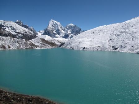


Wednesday, December 15, 2010


Beautiful Pokhara...just as I imagined in EP`s Nepal`s Cafe, yet much much better!
11/25 HAPPY THANKSGIVING Sadly it was cloudy yet again in Pokhara, so no views of the mountains, and maybe just as sad, no Conrad and Whitney to celebrate turkey day with this year, but not all would be lost. Walked from Lakeside to Damside to get my ACAP permit for my next trek. Then walked to Devi’s Falls which is a waterfall that disappears underground and is named after a Swiss fellow who fell in and of course never returned. This year for Thanksgiving I meet up with Sam the Colorado gal who has been living in Pokhara for quite some time working at the orphanage. Since she knew Pokhara well, she took me on a culinary tour of Pokhara. I brought the Nepalese wine (even me, the opposite of a wine connoisseur could tell that the Nepalese haven’t quite figured out what wine is yet. First stop was a restaurant w/ good curd (a type of yoghurt made from yak milk). 2nd stop was a fresh juice place. 3rd stop was apple pancake and potato cheese momos, and apple strudel. Next stop was a fresh Lassi. The following stop was an amazing egg/eggplant/cheese moussaka. Last stop was chocolate apple crumble pie after which we felt stuffed enough to call it a successful Thanksgiving.
11/26 Up at 5am to go for sunrise at the Peace Pagoda. Went w/ 2 chinese women I had met on the bus back from trekking. I was happy to share the cost of the boat, and they were happy to have someone row them. We first paddled across Phewa Tal (lake), then climbed up to the big pagoda on the hill. It was quite cloudy in the distance, so we only got a few glimpses of the big mountains and also foggy over the lake below. But I did have a nice breakfast with the Chinese ladies on the hilltop café by the Peace Pagoda. Spent the rest of the day doing some exploring and hiking around Pokhara Lakeside and Damside and lots of eating at bakeries and yoghurt shops as well as reading.
11/27 Up at quarter to 5. This time no Chinese women to split the cost of the boat, so I walk to damside, catch the first local bus to Chhorepatan to then hiked up to the peace pagoda from there. Bc of waiting for the bus and the longer hike, I am not quite as early as yesterday and this time I am also hiking up the west facing side of the hill. As soon as I make the crest of the hill, I my eyes are struck in the eyes with the bright peak Annapurna range rising over the fog sitting over Phew Lake. Gorgeous! I then visit the Peace Pagoda for even better views of the range as the sun rises and paints the mountains gold. Then it is breakfast at the great rooftop viewpoint restaurant. While eating breakfast, I got to watch this really cool bird that seemed like a parrot and had a cool long tail that it maneuvered funny as it flew. I had been living quite the relaxed travel life for a few days in Pokhara with the bad weather, but now it was back to the normal travel me again. After breakfast I hike down to damside via a jungle trail in which I see some monkeys along the way. By this time, fog has lifted on the lake, so there are nice views of the lake and Annapurnas from the shore. I then hiked back up to the peace pagoda via the jungle trail and now the views of the snowcapped Annapurnas included Pokhara and the blue lake below as the fog had burned off Breathtaking! Just amazing b/c some of the mountains are above 8150m (26,730ft) and Pokhara sits at 884m (2900ft) so that is a rise of 7270m/23,845ft. Compare that to Denver at 5280 ft looking up at Longs 14,250 ft or even like east of Ft. Collins at 4000ish ft where you get a 10,000ft height increase and you can get a better idea of the scale here. It is like looking from Longmont up to Longs Peak and doubling the height and still adding another 5000 feet on top of that as well!! I then walked down to another part of the lake for some views and to read. Then I hiked back up to the Pagoda for sunset and to have some chicken tikka masala from the view restaurant. This was sorta like Déjà vu. Eating at Nepal’s Café in Estes, I always have chicken tikka and admire the views of pokhara and the annapurnas that they have as posters on the wall. My previous boss Judy and my mom Judy used to treat me to Nepal’s and when the Judies took me, I used to look at those pictures and dream of going there so much, which is why it was particularly important for me to wait for good weather here.
11/28 Up at quarter to 5 again. Rented a motorbike and drove up Sarangot hill, a hill between Pokhara and the giant Annapurna Massif. There was a very, very brief, but glowing sunrise b/c high clouds blocked the sun. Everyone had come up in a taxi and they all left in somewhat disappointment. I looked up at the clouds moving rapidly parallel to the mountains w/ blue sky far away, so I waited, and a couple of hours later was rewarded with perfect blue sky, light on the mountains, and light on the rice fields and river valley far below. On the way down, I was invited to an arranged marriage by a Nepali, but I respectfully declined as I had some fresh curd and muesli waiting for me and figured the wedding would be a bit awkward for me. In Pokhara, the mtns were clearer than they had been the whole time I was there, so I took a boat ride on the lake with the mountains towering in the distance. Good views from Pokhara town itself as well. Had a relaxing day around town, then hike in the jungle for a viewpoint of the sunset.
Pokhara is a great town. Quiet, adventure-filled (A Nepali boulder—mtn biking, hiking rafting, kayaking, paragliding access right from town with big mtns nearby) It is a good place to be stuck with cheap and good food and bakeries and a good vibe. And of course those amazing views. Wish when I was waiting for my Lukla flight and sick that I was here instead of in nasty Kathmandu. I am having a bit more of what the brits call a ’holiday ’ here, which is sort of unusual for me. Lots of relaxing and just chilling. Dad’s kind of place with all its newspaper reading, crosswords, bakeries, yoghurt, and tasty tasty chai.
Annapurna Base Camp/Annapuran Sanctuary Trek and Ghorepani loop trek
Well, I have a lot of blogging to catch up on after several weeks out of touch with the internet trekking in the Annapurna region. So again, I am just going to kind of copy straight from the little journal I keep with me, which is just mainly info and a tad bit of rambling, but it should serve the purpose of letting you all know what I have been up to and giving an idea of what it was all about.
11/15 Take the bus from Kathmandu to Pokhara. Bus ride is wild (crazy roads) and scenic of course, following several raging rivers and through junglish terrain. Walk around Pokhara. It’s a nice an quiet town, especially compared to Kathmandu, along Phewa lake. Good and cheap food in Pokhara. Its quite cloudy so there is no seeing the famous mountain views.
11/16 (Day 1) Walk a bit next to the lake, but still no views of the mtns as per the clouds. Hop on a local bus to get to Phedi, but the bus driver forgets to tell me where Phedi is, so I go all the way to Naya Pul and instead start the trek from Naya Pul (1070m/3510ft). Hike from there up to Ghandruk (1940m/6365ft). The hike goes through lots of little villages and lots of rice (and other crop) terraces and a few waterfalls. Nice views down into the deep gorge below, but foggy/thick air, so you can’t see the big mountains =(
11/17 (Day 2) Woke up and looked out my window from my bed to an amazing sunrise setting Annapurna South to a blazing red as well as Macchapulchre (aka fishtail). Very nice! Macchapulchre is the only ’virgin ’ mountain left in Nepal as the government doesn’t allow anyone to attempt to climb it. Today I walk through lots of little villages and rice terraces complete with farm animals of all kinds, interesting houses, lots and lots of flowers, and brightly dressed villagers. I really like walking through the villages. It’s quite a unique experience and a feast for the eyes and other senses. Nice views of the big looming mountains in the morning before the clouds roll in and also nice views into the deep gorges with their raging rivers. Very green and at some places quite jungly. Found a hidden waterfall off of the trail that I spied from a suspension bridge and had to bushwhack to get to. Walked from Ghandruk (1940m/6365ft) to Chhomrong (2170m/7119ft) via Kotdanda (2344m/8288ft) and Kimrongkholagaon (1800m/5904ft). Took the ’long cut’ to get to Chhomrong in order to walk through more villages. I could tell the Ghuesthouses in C-rong would have amazing views, but it is still cloudy. This bad weather is extremely unusual (it is perplexing the locals and guides), and I am praying it passes and goes back to sunny and clear! Had a burrito and hot brownie at a lodge famous for them.
11/18 (day 3) Still cloudy in the morning. Walked to Himalaya Village (2920m/9577ft) along a steep canyon w/ of course a rushing river at the bottom and lots and lots and lots of waterfalls. Walking through rhodendron and monsoon forest. Walking in a very steady and cold rain the last 1.5 hours. My roommate in Himalaya is a nice Chinese guy that shared lots of his Chinese food with me that he brought along including the famous dried Yak from Lijiang that Richard and Sally and I enjoyed so much. Lots of nice people in my lodge that day and we had a really fun night despite the bad weather. New friends: Jude and Casper (Denmark); Jason and Helen (England); and Ondre and Stefani (Slovakia)
11/19 (day 4) Beautiful weather in the morning! Hiking up through the steep canyon. Waterfalls everywhere again. Reached Machhapuchhre Base Camp (3700m/12,139ft) will with clear weather and nice views of Annapurna 1 (8000+m peak), Tare Kang, Ganggapurna, and Machhapuchhre. Strange to have a base camp for a forbidden mountain, eh? By the time I reach Annapurna Base Camp (I am the 1st one there) (4150m/13,616ft), it is snowing pretty decently. Walk around a bit to see the glacier. I am lucky I ascended fast, b/c I was the only one to see the mountains. Snowing hard all afternoon and evening. Hanging out playing cards and reading in the lodge. Lods of fun with the same group as back in Himalaya.
A quote I saw from Ondrej (they just did the ABC trek and did not continue onto the Ghorepani loop like I did) on his facebook wall once I got back to Pokhara that I thought fitting: back from Annapurna base camp trek, 8 long days of wind, rain, snow, clouds, fog and a bit of sun + great people around.. all in all it was an amazing experience! The group, including Ondrej that I was with from Himalaya up were not quite as prepared for mountain weather as I was (some had no sleeping bags, only blankets, others no rain coats, or wind pants or warm jackets), so it was quite the physical test for them. For me it was more of a mental test b/c I wanted to see the mountains, but in the end it all worked out well for me bc by either waiting a day or doubling back I was able to see the mountains clearly from all the big viewpoint areas
11/20 (day 5) Several inches of fresh snow is upon the ground, but gorgeous clear morning!! Get to see the awesome sunrise view from the base camp where the mountains of Annapurna South, Annapurna I, Annapurna III, Tent Peak, Machhapuchhre and others rise straight up from the rock and glaciers there at base camp. Watched some glaciers and avalanches slide down. At the basecamp, you are surrounded by huge peaks in a mountainous amphitheatre. Hike all the way down to Chhomrong (2170m/7119ft) in 1 day (it usually takes two, but with the decent morning weather pattern the past few days, I am hoping to see the views the next day from there) via MC, Derauli, Himalaya, Dovan, Bamboo, and Senua. Of course all the multitude of waterfalls are there going down as they were going up and no less impressive. Drizzling most of the afternoon as I walked through the bamboo forest and jungle. When I get to Chhomrong after a very long day, I had a Cadbury chocolate from the cheap wholesale kerosene depot and a fresh hot brownied from Didi again!! to celebrate making it to ABC. Met Sam (a graduate of Dakota Ridge HS, that’s Colorado Spgs for those non Coloradoans) at Chomrhhong. She is in her senior year at Pamona College (one of the Claremont colleges in CA) but is taking the semester off to volunteer at orphanages in Nepal. Also met Matteus from Germany and had a nice night chatting with them and two other Germans. Skies cleared in the evening and had breathtaking views of the snowy mtns in the full moon!
11/21 (day 6) Amazing views in the morning from Chhomrong looking up at towering Annapurna South and Machhapuchhre. It is especially cool view since Chhomrong village is on a steep rice terraced slope and just across the steep gorge are the towering snowy mountains. I hike through some villages and down a canyon to Kimrongkholagaon (1800m/5904ft) then steeply up through dense rhodendron forest (rhodendron forest reminds me of the temperate rainforests in Washington with cool looking trees and lots of moss). At the end of the day I am hiking through clouds and mist as I reach Tadapani (2630m/8526ft). Nice evening in the lodge with 3 funny Polish, 2 older and sarcastic aussies, and 2 jovial brits).
11/22 (day 7) In the middle of the night when I get up to pee, the full moon on the peakes was stunning with the snow glistening. Sadly, by morning clouds had rolled in so no sunrise or mtn views. I hung out longer than everyone else though b/c it looked like clouds were thinning and I was rewarded with some nice close up views of Annapurna South, Machhapuchhre and others in the range through the clouds. Walked to Ghorephani (2860m/9381ft) via Thulo Odar (2420m/7927ft) where shortly after I saw a couple groups of Langurs (monkeys) in the trees. The majority of this hike was through gorgeous forest along steep cliffs and ravines. Then I went up a long and narrow canyon with a small, clear stream flowing through it that was just gorgeous with the forest transitioning from rainforesty to more of a pine forest. Eventually I reached Ban Thanti (3180m/10430ft), where I had some hot chai before going down a bit and then going up over Deurali Pass (3090m/10,135ft) where the clouds parted a bit and I got good views of the Annapurna range just as I was catching up to my new Japanese friends Masato and Chihiro. Then descended down to Ghorepani (2860m/9381ft) in the mist. Explored Ghorepani a bit and had some delicious Yak Cheese! I am staying at a very nice guesthouse up on the hill with a very warm fire and a nice family. They even had a TV and dvd and we watched Ocean`s 13 at night with popcorn. Met a really nice Chilean gal (Caroline) who is uite adventurous and very friendly and she gave me lots of good tips for the Annapurna circuit. At the guesthouse, it is just me, her, and the Japanese couple, so we have the run of the place. It is very foggy in Ghorepani, but to me the sky looks somewhat light directly overhead and thinking that a bit higher up I might be able to get out of the fog, I go for the hike up to the top of Poon hill (3210m/10528ft) and am rewarded with amazing sunset views over the entire Annapurna range and Dhaulagiri (8172m, worlds 7th highest mtn) with some high clouds lit up above and fog below in the valleys and gorges. Very beautiful! And also amazing b/c I am all alone up there, so it is nice and quiet. As poon hill can just be an easy 3 day loop and it has one of the best views of the range and does not have the altitude or cold weather problems, it is an extremely popular trek and the next morning there would be over 100 people on top of poon hill taking away from the serenity of a peaceful mountain sunrise.
11/23 (Day 8) Leave at 5:15am to climb poon hill for sunrise with Caroline and the Japanese couple. Snowing and sleeting at the top unfortunately, so no views. I meet two of Carolina’s friends from her circuit trek at the top: Polly and Artie from Donnelly, ID, though they had met when they lived in CO—Artie working at Breck and Polly at the YMCA of the Rockies in Estes. Now they are photographers working in Whitefish and McCall/Tamarak. Though they are looking to move since Tamarak closed (wow, I had no idea, look what happens when you travel abroad for so long) and a lot of their business was weddings there. I don’t know how much they were exaggerating or not, but they said you can get houses dirt cheap in Donnelly now (50,000 dollars) or on the actual slope for 200,000. This seemed like an amazing opportunity/possibility bc in my best guess a ski resort will come back there. I guess the French guy who ran it, just was poor at managing it. Plus, I think that Idaho is going to eventually go the way of Colorado in that it is being discovered now and will se a huge population boom, especially in the treasure valley and bogus basin and Brundage will not be enough ski resorts to support the budding outdoor enthusiast population so they will need more ski resorts. We also talked about working in Antarctica as they want to as well and they gave me some contacts of people they knew who had worked there and might have some advice for getting a job. They also told me about a sweet idea of if you work in a town with an airport to work like 1 shift a week doing check in or baggage or something for an airline and you get to fly for free standby anytime you want anywhere the airline or its code share partners fly. They don’t do it, but Polly’s sister does and she also gets to give immediate family members free standby flights and that is how they are traveling. That sounds totally awesome to me! On top of poon hill I joined in on a jumping photo with Polly who is jumping for a photo everyday of the year. If you want to check out her jumps go to http://www.facebook.com/pages/Jumping-Polly/120796064605428 and check out her albums. Those in Idaho/Montana may be particularly interested to see some of the places she has jumped up there. Had a good breakfast w/ the three of them talking about Idaho, CO, Patagonia and Antarctica. The Japanese and I decided to stay another day to hope for the infamous sunrise views from Poonhill. Masato and I hike towards Tatopani (as opposed to Tadapani). We go through lots of nice agricultural and farmland and reach the villages of Chitre (2390m/7447ft) before going back up. I hike back up to the top of Poonhill even though I know it will be foggy and have no views, but just to do something and get a good workout. I don’t minde staying an extra day here bc I love the guesthouse I am staying at and the food is amazing there!!
11/24 (Day 9) Amazing day1 Walked up to Poon hill early again with the Japanese couple to see sunrise. Gorgeous sunrise w/ spectacular vies of the Annapurna range gloing pink, Back down in Ghorepani (also with nice views), I have apple crumble pie for breakfast to celebrate, outside in the bright sunshine. Then walked the long way down to Naya Pul at 1070m/3510ft (so lost 7018ft) in one day! Go through lots of picturesque villages like Banthanti (2250m/730ft, Ulleri (1960m/6429ft) and Hille. These villages were really cool b/c there was lots going on in them from making millet for local spirits to plowing fields with buffalo (not so jovial bison) to kids playing around and trying to sell me oranges. Lots of villagers dressed in colorful garb and flowers and poinsettias everywhere. Add this to the green backdrop and rice terraces and distant snow-capped peaks and it was just purely fantastic. Even some macaque monkeys running through the forests between the villages. Lower down there was lots of agriculture and non-stop villages, all w/out roads of course. Just subsidence farmers. Back at Naya Pul again, I get some fresh oranges and then take the bumpy and winding road back to Pokhara. I have a `pre` Thanksgiving and welcome back to civilization feast with lassies, chais, good food, and chocolate. I had enquired at a guesthouse for rooms, but all they had were expensive rooms left, so instead the owner let me stay with his family in a cool homestay.
Subscribe to:
Posts (Atom)

